From Wikipedia, the free encyclopedia
Jump to: navigation, search
| | This article is in need of attention from an expert on the subject. WikiProject Geology or the Geology Portal may be able to help recruit one. (May 2008) |
Coordinates:  907'16?N 7931'18?E? / ?9.1210N 79.5217E? / 9.1210; 79.5217

Ram Sethu as seen from the air
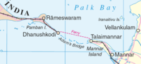
Adam's Bridge (Tamil: ????? ????? atham palam), also known as Rama's Bridge or Ram Setu (Tamil: ?????? ????? iramar palam, Sanskrit:??????? ramasetu)[1], is a chain of limestoneshoals, between the islands of Rameswaram, off the southeastern coast of Tamil Nadu, India, and Mannar, near northwestern Sri Lanka. Geological evidence indicates that this bridge is a former land connection between India and Sri Lanka.[2]
The bridge is 30 miles (48 km) long and separates the Gulf of Mannar (southwest) from the Palk Strait (northeast). Some of the sandbanks are dry and the sea in the area is very shallow, being only 3 ft to 30 ft (1 m to 10 m) deep in places, which hinders navigation.[2]
[3][4].
| Contents[hide] 1 Name 2 Location 3 Transportation and navigation 4 Geological evolution and age 5 Early surveys and dredging efforts 6 Sethusamudram shipping canal project 7 Controversies 8 See also 9 References - 10 External links
|
[edit] Name
The 13th century Venetian traveller Marco Polo's travel map shows that he travelled around the Adam's bridge area. His travel book calls this area Setabund-Rameswara.[1] which means bridge constructed at Rameswaram. The bridge was first mentioned in historical works in the 9th century by Ibn Khordadbeh in his Book of Roads and Kingdoms (ca. 850 AD) and was called Set Bandhai or "Bridge of the Sea".[5]. Later Alberuni described it.
The name Rama's Bridge or Rama Setu (Sanskrit; setu: bridge) was given to this bridge of shoals in Rameshwaram, as Hindu legend identifies it with the bridge built by the Vanara (monkey-men) army of Rama , which he used to reach Sri Lanka and rescue his wife Sita from the Rakshasa king, Ravana, as stated in the Sanskrit epicRamayana.[6]. It is called as Adam's Bridge in the west and the name probably comes from an Islamic legend, according to which Adam used the bridge to reach Adam's Peak in Sri Lanka, where he stood repentant on one foot for 1,000 years, leaving a large hollow mark resembling a footprint. Both the peak and the bridge are named after this legend. [2][6]
The sea separating India and Sri Lanka is called Sethusamudram "Sea of the Bridge". Maps prepared by a Dutch cartographer in 1747, available at the TanjoreSaraswathi Mahal Library shows this area as Ramancoil, a colloquial form of the Tamil Raman Kovil (Rama's Temple)[7] Another map of Mogul India prepared by J. Rennel in 1788 retrieved from the same library called this area the area of the Rama Temple [8] Many other maps in Schwartzberg's historical atlas[9][10] and other sources call this area with various names like Koti, Sethubandha and Sethubandha Rameswaram along with others.[11][12][13][14]. Valmiki Ramayan called the bridge built by Lord Rama Setu Bandhanam in verse 2-22-76[15].
The earliest map that calls this area Adam's bridge was prepared by a British cartographer in 1804.[16]
[edit] Location
Adam's Bridge starts as chain of shoals from the Dhanuskodi tip of India's Rameswaram Island and ends at Sri Lanka's Mannar Island. Rameswaram Island is connected to the Indian mainland by 3 km long Pamban Bridge. Ramasetu and neighbouring areas like RameswaramDhanushkodi, Devipattinam and Thirupullani are mentioned in the context of various legends in Ramayana. [2][3][4].
[edit] Transportation and navigation
Rameswaram (Tamil Nadu, India) is an island port about 2 km from mainland India. The Pamban Bridge links Rameswaram island with mainland India. It refers to both : A road bridge and a cantilever railway bridge. Small boats would go below the 2065m long road bridge and the railway bridge would open up.
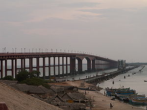
Pamban Bridge
Rail Bridge from India Mainland to Rameshwaram
The problem in navigation exists because big ships can't travel in shallow waters. Dredging in this channel would cost greater than dredging a channel in the Adam's bridge area, where the waters are comparitively deep and lesser earth would have to be dredged. Hence, in 2001, the Government of India approved a multi-million dollar Sethusamudram Shipping Canal Project that aims to create a ship channel across the Palk Strait cutting across the Adam's bridge. Various organizations have opposed the project based on religious, economic and environmental grounds and have sought the implementation of one of the alternative alignments considered during the earlier stages of the discussion.
A ferry service links Rameswaram in India with Talaimannar in Sri Lanka. The service was part of the Indo-Lanka Railway service during the British Rule. One could buy a railway ticket from Chennai to Colobmo, whereby you travel by rail from Chennai to Rameswaram island, go by ferry to Talaimannar, and then go again by rail to Colombo. The ferry service has been suspended for some time because of the fighting between Sri Lankan government forces and the separatist LTTE.
[edit] Geological evolution and age

Landsat 5 image of Adam's Bridge
Studies have variously described the structure as a chain of shoals, coral reefs, a ridge formed in the region owing to thinning of the earth's crust, a double tombolo,[17] a sand spit, or barrier islands. It has been reported that this bridge was formerly the world's largest tombolo before it was split into a chain of shoals by the rise in mean sea level few thousand years ago.[18] The geological process that gave rise to this structure has also been attributed to crustal downwarping, block faulting, and mantle plume activity by one study[19] while another theory attributes it to continuous sand deposition and the natural process of sedimentation leading to the formation of a chain of barrier islands related to rising sea levels.[20] Yet another theory affirms that the origin and linearity of the Ram Setu may be due to the old shoreline – implying that the two landmasses of India and Sri Lanka were once connected – from where coral reefs evolved. Marine and Water Resources Group of Space Application Centre, ISRO based on satellite remote sensing data, without actual field verification concluded that Adam's Bridge comprises 103 small patch reefs lying in a linear pattern with reef crest (flattened, emergent – especially during low tides – or nearly emergent segment of a reef), sand cays (accumulations of loose coral sands and beach rock) and intermittent deep channels. The coral reefs are designated by the different studies variously as ribbon and atoll reefs.
The origin of the structure has been explained as being due to longshore drifting currents which moved in an anticlockwise direction in the north and clockwise direction in the south of Rameswaram and Talaimannar. The sand was supposedly dumped in a linear pattern along the current shadow zone between Dhanushkodi and Talaimannar with later accumulation of corals over these linear sand bodies. In a diametrically opposing view, another group of geologists propose crustal thinning theory, block faulting and a ridge formed in the region owing to thinning and asserts that development of this ridge augmented the coral growth in the region and in turn coral cover acted as a 'sand trapper'. The tombolo model on the other hand affirms a constant sediment source and a strong unidirectional or bi-directional (monsoonal) longshore current. One study tentatively concludes that there is insufficient evidence to indicate eustatic emergence and that the raised reef in south India probably results from a local uplift.[21]
Some geologists have stated that this structure is a natural one whereas others believe that this structure is man-made. The Madras High Court has said that this bridge is man-made,[22] while the Government of India in an affidavit in the Supreme Court of India, said that there is no historical proof of the bridge being built by Ram, to bolster their plan to implement the Sethusamudram Shipping Canal Project.[23]
According to V. Ram Mohan of the Centre of Natural Hazards and Disaster Studies of the University of Madras "reconstruction of the geological evolution of the island chain is a challenging task and has to be carried out based on circumstantial evidence".[20] The lack of original evidence explains many of the uncertainties regarding the nature and of Adam's Bridge, which consists of a series of parallel ledges of sandstone and conglomeration that is hard at the surface and grows coarse and soft as it descends to sandy banks. Considerable diversity of opinion and confusion exists about the nature and origin of this structure. In the 19th century, there were two prevalent theories explaining the structure. One considered it to be formed by a process of accretion and rising of the land, while the other surmised that it was formed by the breaking away of Sri Lanka from the Indian mainland.[24] The friable calcerous ridges are broken into large rectangular blocks, which perhaps gave rise to the belief that the causeway is an artificial construction.[25]
The scientific age determination of the structure is also mired in confusion. A team from the Centre for Remote Sensing (CRS) of Bharathidasan University, Tiruchi, led by Professor S.M. Ramasamy dates the structure to 3,500 years.[26] They also claim that the carbon dating of some ancient beaches between Thiruthuraipoondi and Kodiyakarai show the Thiruthuraipoondi beach dates back to 6,000 years and Kodiyakarai around 1,100 years ago. Another study suggests that the appearance of the reefs and other evidence indicate their recency, and a coral sample gives a radiocarbon age of 4020160 years B. P.[21] The GSI carried out a special programme called "Project Rameswaram" that concluded that age data of corals indicate that the Rameswaram island has evolved since 125,000 years ago. Radiocarbon dating suggests that the domain between Rameswaram and Talaimannar may have thus been exposed sometime between 18,000 and 7,000 years ago.[20] Other studies also conclude that during periods of lowered sea level over the last 100,000 years, Adam's Bridge has provided an intermittent land connection between India and Sri Lanka, which according to famous ornithologistsSidney Dillon Ripley and Bruce Beehler supports the vicariance model for speciation in some birds of the Indian Subcontinent.[27]Thermoluminescence dating by GSI however concludes that the sand dunes of Dhanushkodi to Ram Sethu started forming only about 500-600 years ago.[20]
Tsunami expert Professor Tad S Murty has stated that Rama's bridge might have acted as a protection wall during the Indian Ocean Tsunami event in 2004, because of its elevation, and prevented damage to South Kerala. He states however that this view is not based on his own original research, nor is he aware of any such studies being carried out by anyone.[28]
[edit] Early surveys and dredging efforts
Owing to shallow waters, Ram Setu presents a formidable hindrance to navigation through the Palk strait. Though trade across the India-Sri Lanka divide has been active since at least the first millennium BC, it has been limited to small boats and dinghies. Larger ocean-going vessels from the West have had to navigate around Sri Lanka to reach India's eastern coast.[29] Eminent British geographer Major James Rennell, who surveyed the region as a young officer in the late eighteenth century, suggested that a "navigable passage could be maintained by dredging the strait of Ramisseram [sic]". However little notice was given to his proposal, perhaps because it came from "so young and unknown an officer", and the idea was only revived 60 years later.[30]
In 1823, Sir Arthur Cotton (then an Ensign), was trusted with the responsibility of surveying the Pamban channel, which separates the Indian mainland from the island of Rameswaram and forms the first link of Ram Setu. Geological evidence indicates that this was at one point bridged by a land connection, and some temple records suggest that the connection was broken by violent storms in 1480. Cotton suggested that the channel be dredged to enable passage of ships, but nothing was done till 1828, when some rocks were blasted and removed under the direction of Major Sim.[31][32]
A more detailed marine survey of Ram Setu was undertaken in 1837 by Lieutenants F. T. Powell, Ethersey, Grieve and Christopher along with draughtsman Felix Jones, and operations to dredge the channel were recommenced the next year.[31][33] However these, and subsequent efforts in the 19th century, did not succeed in keeping the passage navigable for any vessels except those with a light draft.[2]
[edit] Sethusamudram shipping canal project
Main article: Sethusamudram Shipping Canal Project
Opposition parties are demanding implementation of the Sethusamudram canal project using one of the 5 alternative alignments considered by Government earlier without damaging Ramsetu's structure. The Sethusamudram project committee in 1956 also strongly recommended to the Union government to use land passages instead of cutting Adam's bridge because of the several advantages of land passage.[34]
The government of India constituted nine committees before independence, and five committees since then to suggest alignments for a Sethusamudram canal project. Most of them suggested land-based passages across Rameswaram island and none suggested alignment across Adam's bridge.[35]
In 2001, the Government of India approved a multi-million dollar Sethusamudram Shipping Canal Project that aims to create a ship channel across the Palk Strait by dredging the shallow ocean floor near Dhanushkodi. The channel is expected to cut over 400 km (nearly 30 hours of shipping time) off the voyage around the island of Sri Lanka. This proposed channel's current alignment requires dredging through Rama's Bridge.
Political parties including the Bharatiya Janata Party (BJP), All India Anna Dravida Munnetra Kazhagam (AIADMK), Rashtriya Janata Dal (RJD), Janata Dal (Secular) (JD(S)) and some Hindu organizations oppose dredging through the shoal on religious grounds — Rama's Bridge being popularly identified as the causeway described in the Ramayana — and suggest using an alternate alignment for the channel that avoids damage to Adam's Bridge.[36][37] The state and central government have opposed such changes, with Union Shipping Minister T R Baalu saying the current proposal was well scrutinised for economic viability and environmental sustainability and that there were no other environmentally feasible alternatives.[38][39][40]
Opposition to dredging through this causeway also stems from concerns over its impact on the area's ecology and marine wealth, potential loss of thorium deposits in the area, and increased risk of damage due to tsunamis.[41]. Some organizations are completely opposing this project on economical and environmental grounds and claim proper scientific studies were not conducted before undertaking this project.[42]
[edit] Controversies
NASA satellite photo of Rama's Bridge—oblique, Sri Lanka to the left
| | It has been suggested that this section be split into a new article entitled Sethusamudram_Shipping_Canal_Project#Religious. (Discuss) |
Certain historical inscriptions, old travel guides, old dictionary references and some old maps have reinforced the religious and geographical belief of this structure being the ancient bridge that is considered with great regard by the Hindus in the Indian Subcontinent.[43][44] This conjecture must be tempered with the fact that there are no geographical pointers to the structure being Rama's Bridge in any of the ancient texts or Puranas. Vaishnava News Network and some other U.S.-based news services suggested that they had discovered the remains of the bridge built by Rama and his Vanara army that is referred to in the Ramayana, and that it was not a natural formation, basing their claim on 2002 NASA satellite footage.[45] NASA distanced itself from the claims saying that what had been captured was nothing more than a 30-km-long, naturally occurring chain of sandbanks.[46] It also clarified that, "The images reproduced on the websites may well be ours, but their interpretation is certainly not ours. Remote sensing images or photographs from orbit cannot provide direct information about the origin or age of a chain of islands, and certainly cannot determine whether humans were involved in producing any of the patterns seen.[47]
A team from the Centre for Remote Sensing (CRS) of Bharathidasan University, Tiruchi led by Professor S.M. Ramasamy in 2003 claimed that, "Rama's bridge could only be 3,500 years old" and, "as the carbon dating of the beaches roughly matches the dates of Ramayana, its link to the epic needs to be explored".[48] However, one needs to note that the surveys which have come out with the 3500-year age for the bridge are based on the studies conducted on corals grown on the bridge itself and it has been argued that this represents only the age of what was measured, which is the corals. The bridge underneath the corals has been dated back to hundreds of thousands of years earlier. A former director of the Geological Survey of India, S. Badrinarayanan, claims that such a natural formation would be impossible. He justifies the same by the presence of a loose sand layer under corals for the entire stretch. Corals normally form above rocks.[49] [50] He feels that thorough analysis was not conducted by the Geological Survey of India before undertaking the SSCP project. In connection with the canal project, the Madras High Court in its verdict stated that the Rama Sethu is a man-made structure.[51].Geological and archaeological findings of Teri formations, a rich assemblage of Mesolithic-Microlithic tools and human fossils found on both sides of the bridge by the Department of Earth-Science in March 2007 are also quoted as evidence for manmade structure.[52][53][54][55]
Prof. N. Ramanujam, Head, Post-Graduate Department of Geology and Research Centre, V.O. Chidambaram College, astrophysicist Jayant Narlikar and a group of professors of Madurai Kamaraj University (which is in the state of Tamil Nadu and is directly under the control of the state ministry of education) stated that Rama's bridge is a natural geographical feature which formed some 17 million years ago.[45][56] In addition, the Archeological Survey of India has said that the structure is not man-made. A government publication from National Remote Sensing Agency, which was recently tabled in the Indian Parliament, says that the structure "may be man-made".[57][58] The Congress Government, in 2006, stated that Rama himself destroyed the bridge that he had built.[59]


 CID
CID

